Avonmore
The Avonmore demonstration catchment is a sub catchment of the Avonmore River which rises in the Wicklow mountains and flows in a South Easterly direction before turning South and joining the Glendasan river near Glendalough.
The Avonmore demonstration catchment is a sub catchment of the Avonmore River which rises in the Wicklow mountains and flows in a South Easterly direction before turning South and joining the Glendasan river near Glendalough.

The Avonmore sub-catchment covers 141km2 of Wicklow. We estimate about 2,000 people
live here based on the 2022 census.
It is mainly an upland region with land-use including forestry and 135 farms. Soil type includes a mix of peat, poorly drained soils and well drained soils.
The sub-catchment is divided into 7 river water bodies and 3 lake water bodies:
EPA data shows that water quality in the Avonmore sub-catchment is
mixed.
Cloghoge brook and the upper sections of the Avonmore only have moderate water quality and we need to restore them.
The Glenmacnass and the lower sections of the Avonmore are healthier and we need to protect their status.
The EPA assigns each water body an ecological status for water quality. They are then given an objective to have good or high status by 2027.
This is based on our Water Framework Directive legal requirements. A risk assessment works out how likely it is for a water body to meet its objective. Some of these rivers are at risk of not meeting their objectives for water quality.
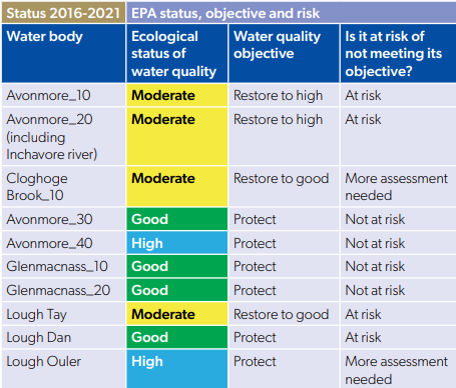
Historically these rivers have been at high ecological status which means they have the potential to achieve and maintain high conditions. With the change down to good ecological status we know that these rivers are at stress and need action for the restoration.
However, it should also be noted that a third waterbody in the sub catchment has improved to high status and has been high during two monitoring cycles.
The significant pressures in the catchment are forestry and agriculture. This catchment was chosen in consultation with Coillte and the Forest Service as there is likely to be significant forestry activity in the area during the life of the project and will allow appropriate management strategies for high status areas to be developed.
Mark Desmond – Catchment Ecologist
Phone: +353861986343
Email: mark.desmond@housing.gov.ie